
Above the Clouds: Hiking Mera Peak
Above the Clouds: Hiking Mera Peak
Hiking Mera Peak
In the northeast of Nepal, Mera Peak stands at an imposing 6,476 m and is the country’s highest trekking route. It is located in the Mahalangur section of the Himalayas bordering the Khumbu region, home to Sagarmatha (Mt. Everest). Each year, hundreds of visitors undertake the journey to Mera Peak, which traverses some of Nepal’s most spectacular mountain scenery.
Overview
The hike to Mera Peak takes approximately 10 days, beginning in Lukla and including one rest / acclimatisation day at Khare (5,000 m / 16,404 ft). As the country’s highest trekking route, no mountaineering experience is needed, however, crampons, snow boots, or ropes may be required depending on weather conditions.

Views from the summit of Mera Peak
Mera Peak facts
Height: 6,476 m / 21,246 ft
Duration: 10 days
Length: 125 kms / 77.5 miles (approx.)
Elevation gain: 3,616 m / 11,863 ft (Lukla to Mera Peak Summit)
Mera Peak history
The Mera Peak region was explored and mapped in the early 1950s by teams of mountaineers that included Edmund Hillary and Tenzing Norgay. The first ascent of the mountain was completed in 1953 by British mountaineer Colonel Jimmy Roberts and his Nepali offsider Sen Tenzing. The pair reached Mera Peak Central at a height of 6,461 m (21,198 ft). The first team to reach the true summit, Mera Peak North (6,476 m / 21,246 ft), was the Frenchmen Marcel Baus and L. Honills in 1975. Following his ascent, Colonel J.O.M. Roberts became involved in developing the trekking industry in Nepal and was posthumously recognised with the Sagarmatha National Award in 2005.
How to get to Mera Peak
The starting point for Mera Peak is the town of Lukla. Flights from Kathmandu take approximately 45 minutes and can be arranged independently or through a trekking company. The infamously unpredictable weather often results in flights being delayed, turned around, stopping in Ramechhap, or being cancelled altogether. It is possible to reach Lukla by road from Kathmandu, via Ramechhap, however this involves long and arduous journeys on unstable and dangerous mountainside roads.
Lukla airport
Mera Peak accommodation
Nepal’s famous tea houses are dotted along the route to Mera Peak, except for High Camp where hikers spend the night in tents. Most rooms at tea houses are twin share, and hot and cold showers are available – at a price. The restaurants and communal areas are well set up, with ample space to relax, read a book, and meet other travellers. Heating is rudimentary, with potbelly stoves in the communal areas and little else. Extra blankets are available for cold nights. The meals in the tea houses are excellent. The portions are substantial, the food is fresh and tasty, and there is a wide variety of meals. Internet is available sometimes, most reliably in Khare, and phone charging services are available at most tea houses (expect to pay handsomely for these luxuries).

Thuli Kharka camp
Skill Level
As the highest trekking route in Nepal, Mera Peak is an attractive proposition for hikers who do not have mountaineering experience. However, Mera Peak is still a difficult climb. The most challenging part of hiking Mera Peak is the altitude. On the second day, the Zatrwa La pass rises to 4,600 m and can be a tough initiation at the beginning of the hike. The trek from Khare to High Camp is a jump of almost 800 metres in a day, and there are no luxuries at High Camp. The toilet is perhaps the most infamous example. Finally, the summit walk is completed in the dark and in the cold, with the chance of high winds on the exposed peak.
For my tips on hiking at altitude, you can read Top 10 Tips for Altitude Hiking, which has been updated since I completed Mera Peak.
Essential gear for hiking Mera Peak
Hiking poles
Thermals
Softshell jacket
Headtorch
Snow spikes
What it’s like to hike Mera Peak
It is approaching dawn in Kathmandu, and the foyer of Hotel Thamel Park is buzzing with nervous anticipation. Guides and porters haul bright yellow North Face bags from the foyer to minibuses outside, and excited travellers check and recheck their daypacks and supplies. Should I put my jacket on now? Do I need more food? Can I refill my water? Do we have time to go to the toilet? The buses depart under brightening skies and head toward Kathmandu airport, moving through the rapidly emerging traffic.
We depart Kathmandu mid-morning, having waited for clouds to disperse and the winds to subside. Our flight time is estimated at 45 minutes, however, 20 minutes into the journey, there is a change of plan. The air hostess regrets to inform us that we will be landing at Ramechhap, halfway to Lukla. We spend three hours in Ramechhap airport and then reboard and try again.
The plane glides through wispy clouds with the consistency of fairy floss. Far below, rivers of blue and grey snake through the valleys. The scattering of villages resembles Lego brick constructions, with ant-like people and cars scurrying about. The runway at Lukla airport is 527 metres long, half a kilometre, with planes literally flying on and off the edge of the mountain. The landing gear clunks into place as we approach, and the plane sways in the wind. It touches down and the brakes screech loudly, working overtime as we slide along the tarmac. It is as smooth a landing as one can hope for in Lukla. The cabin erupts in applause, and nine hours after we first gathered in Kathmandu, we have arrived.
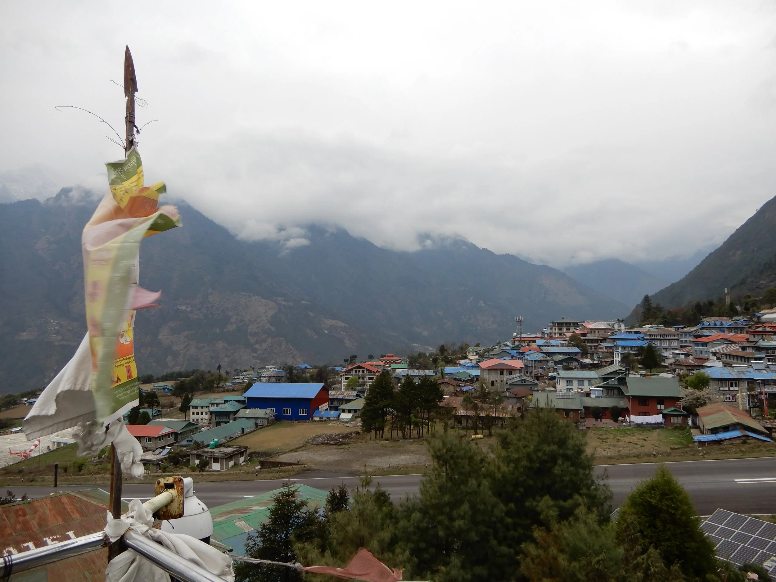
Day 1: Lukla to Thukding
After a short break in Lukla, the first leg of the journey commences. Gombu Sherpa, who last walked this trail a year ago, leads me through the cobbled pathways of Lukla and into the mountains. We cross a large suspension bridge adorned with tattered prayer flags and skip over makeshift wooden bridges covering creeks. It has been a blustery day, and storm clouds rumble overhead. The path undulates along a rocky mountain path, and after an hour of walking, it begins to rain. A sign nailed to a tree reads ‘Chutunga 30 mins.’ The sky darkens and the rain intensifies as we arrive at Thukding. Gombu suggests we stay, and I do not need convincing. It has been a long day, and we both need a rest. Tomorrow’s climb is more than a thousand metres in elevation, over the Zatrwa La pass.
The kitchen hut at Thukding
Day 2: Thukding to Tuli Kharka
The trail to Zatrwa La Pass is covered in a film of freshly fallen snow. The mountains tower over us, daring us to venture upwards. The imposing view is the first image I see in the morning, and it is equal parts exhilarating and daunting. High winds push the clouds away and reveal the full majesty of the mountains. The enormous walls of rock grow ever barer the higher they stretch.

Thukding to Zatrwa La Pass
After a breakfast of muesli and warm milk, we set off, trudging slowly upwards. Soon, the familiar symptoms of altitude sickness resurface. My stomach contorts and my head throbs. I stop to rest and lean on my walking poles. I have never felt these symptoms so early, so low, and I am despondent. When we reach the pass, I feel miserable. The clouds have obscured the view and ragged prayer flags hang limp. We encounter a German couple on their way who failed to summit. Perhaps I won’t make it? If I’m feeling the effects this low, then how will I feel at 5,000m, or 6,000m? It is far from the ideal beginning to the trek. From the pass, it is a quick, though careful descent to Tuli Kharka. The afternoon is spent reading, drinking tea, and recovering. The symptoms subside, though my doubts linger.

At the Zatrwa La Pass, not feeling too great
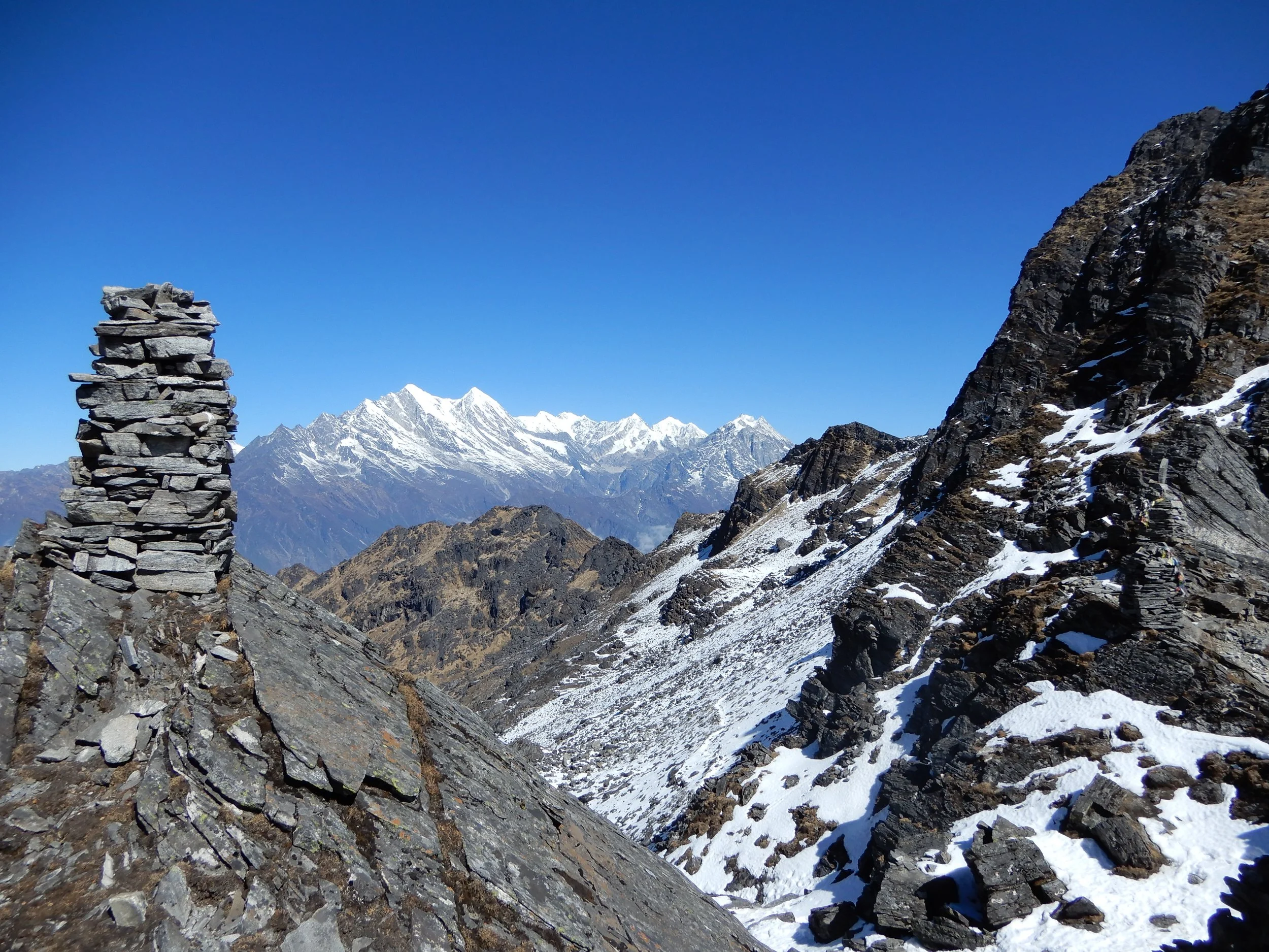
Day 3: Tuli Kharka to Kothe
Sparkles of sunshine glisten on the morning snow. Cold winds sweep downwards, brushing powder off the mountaintops. The undulating trail from Tuli Kharka offers spectacular views of the Himalayas, and the snow crunches under our feet. My spirits are buoyed as we traverse the mountainside, and my gaze is fixed on the jagged, snowcapped horizon. Cairns are dotted along the route, and the final one, wrapped in faded prayer flags, signals our descent into the valley.
A zigzag path snakes through forests of juniper, and soon we are below the snowline. At the village of Taktor (3,600 m), we stop for a morning tea break, and my knees are thankful for the break. From Taktor, the trail leads up and follows a tributary of the Hinku Khola River, fed by the melting Himalayan snow. In parts, it trickles, while in others it gushes. When we reach Kothe, the clouds roll in, and it appears that another afternoon of snowfall is imminent. I settle in and enjoy a yak steak for lunch.

Morning, not far from Thuli Kharka
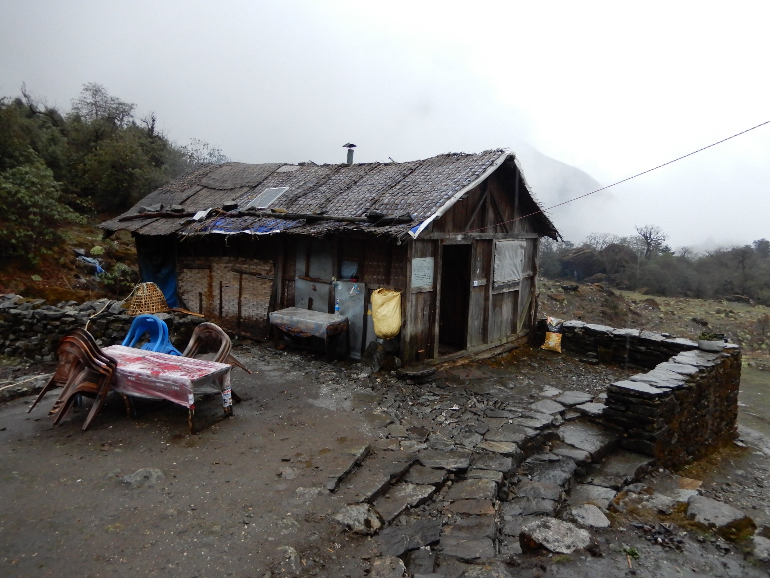
Day 4: Kothe to Khare
Kothe sits at the junction of Mera Peak’s two ascending trails. The alternate route, lower and longer, avoids the Zatrwa La pass. As such, Kothe is the busiest tea house so far, populated with climbers coming and going from all directions. One of those is an Australian man (who also failed to summit), and he has been coughing and spluttering all night.

Valley walk from Kothe to Khare
I wake with a runny nose and sore throat. The morning sun is a small comfort as we walk through the valley, with views of even greater peaks ahead. After a couple of hours, we reach a Buddhist monastery built into the side of the mountain, and Gombu stops to burn some incense. We break for lunch at Thangnak, and I can feel my energy waning. I am craving soup and sleep, yet we have several more hours to walk. Gombu is pushing us a day ahead of schedule in a race against the weather. The promise of a rest day is all the motivation I need to push on. As with all the previous afternoons, and especially as we approach 5,000 m, the clouds converge. The power of the sun is dimmed, and when we reach Khare, I feel a slight headache, an accompaniment to my sniffles. After two good days, my doubts about reaching the summit rekindle.
Day 5: Rest and acclimatisation day
The blue sky glows through the curtainless windows and the sound of helicopters echoes through the valley. I sit up in my sleeping bag and blow my nose. The handkerchief is splattered with blood. This is not uncommon at altitude, though alongside my sore throat and general malaise, it dents my confidence. When I see Gombu, I share my doubts and tell him I am 50/50 for the summit. He barely acknowledges my doubts and tells me that in the afternoon we will fit the snow boots and harness required for the final section, High Camp and the summit. I spend the rest of the day doing exactly what I feel like doing: nothing. Other hikers take short trips up the hills around Khare to help with their acclimatisation. Gombu says there is no need for me to do it. He appears to have far more confidence in me summitting than I do. By evening, it feels as though whatever bug I had has gone, and I feel as ready for the attempt as I can be.

Khare, Mera Peak
Day 6: Khare to High Camp
‘Leave your shoes here,’ Gombu instructs. Another overnight dumping of snow means we will walk in snow boots all the way to the summit. First, though, we must reach High Camp. The first section of the trail is rocky, and the pace is slow as we negotiate the twists and turns in spiked boots. The morning sun is warm and comforting, encouraging us up the mountain face. We stop for a rest at Base Camp and then bid farewell to the rocky path and embrace the snow. What looms in front of us is an enormous wall of white. An unending ascent to the heavens. A series of footprints in the snow marks the route. As we set off, the clouds coalesce, sweeping over the horizon and rising from below. All that is ahead and around us is white, save for the coloured figures crawling up and down the mountainside.

Khare to High Camp
The walk to High Camp is slow and uninteresting, with little to focus on except our footsteps. After many long and arduous hours, we round a rock face and spy the bright yellow North Face tents that occupy a permanent position on the mountain. My head is throbbing, and my body is fatigued. The altitude catches up with me. Kept at bay while we walked, it now crashes over me, like a surprise wave when swimming in the ocean. High Camp is 100 metres lower than Mt. Kilimanjaro, the highest I have ever been. Inside the kitchen tent, I force down a bowl of soup and several cups of tea. There are fleeting moments of sun that transform the tents into ovens. Otherwise, the temperature hovers around zero or below. Can I have another rest day?

High Camp, Mera Peak
Day 7: High Camp to Summit, return to Khare
It is 1:00 am when the calls ring out. We are stirred from our slumber, and torch lights flash throughout the campsite. Having slept in my hiking clothes, I need only to add a top layer and then drag myself out of the tent. Nothing is easy at High Camp. A slight headache persists, as do the bloody boogers, and it is in these moments that you wonder why you do these things. Why have I come to climb this mountain, in the dark, in the snow, in subzero temperatures? Why do I put myself through this?
At sunrise, after hours of walking through the dark, through the snow, and through subzero temperatures, I am reminded of the answer. The rounded, pure white summit of Mera Peak appears before us. Illuminated by the rising sun, it glows like a shining prize. Our victory is not one of conquest, but of witnessing the splendour of a Himalayan dawn. Overhead, the sky transforms from black to a colourless grey and then a striking blue. Behind us, panoramic views of the Himalayas are revealed. There is Lhotse and Nuptse, Cho Oyu, Makalu, and Kanchenjunga, and the mother of them all, Sagarmatha, Mt. Everest.

With Gombu Sherpa, at the summit of Mera Peak
On the summit, which is much smaller than I expected, Gombu and I shake hands and then embrace. There were many times when I thought I wouldn’t be standing here, and I hunch over on my poles, relieved and thankful. Gombu pushed us a day ahead of schedule, and he has timed this climb perfectly. There is not a cloud in the sky and not a breath of wind. The joy on his face is more akin to a man who is summitting for the first time, not the umpteenth.
As more climbers ascend, we must make way and drop down to a lower point where we can rest and bask in the morning view. Under the warming sun, our fingers and toes thaw, tingling as feeling returns. More climbers pass us, and we encourage them up the final stretch. The elation of summitting overtakes the feelings of weariness and hurt. I have never felt as strong and as weak at the same time.

Looking back towards the summit
Down at High Camp, the mood is euphoric. That we barely slept last night and have not showered in almost a week matters not. The fatigue and nervous energy of yesterday has vanished completely. In this moment we are reborn, having walked higher than we ever have before. We did it.
Day 8: Khare to Kothe
The downside of climbing mountains is, of course, the downside, descending. My knees are in for a rough couple of days. Although the descent is countered with an upside, and that is the vanishing symptoms of altitude sickness. From Khare (5,000m), the walk down to Kothe is more enjoyable because of this, and there is an extra skip in our step having summitted. The sun feels warmer, and the sky appears bluer. Camp dogs follow us down the trail, and Gombu tells me that he has seen them as high as High Camp. Do dogs get altitude sickness?
At Kothe, there is another coughing, spluttering person in the teahouse, this time a porter. I suggest to Gombu that we give him some medication as he looks as though he is about to fall off his chair. Gombu laughs at the suggestion, ‘He does this all the time, too much drinking and smoking.’

Passing by the monastery on the return to Kothe
Day 9: Kothe to Tuli Kharka
There has been no snowfall for several days, and the trail to Tuli Kharka is like walking on a different mountain. In the valley, the same rivers are trickling and gushing, yet the upper reaches of the mountain are bare. We break for an early lunch at Taktor and then push towards Tuli Kharka on naked trails. Clouds hover, yet they pose no threat. The cairns are the only familiarity on the trail, and it is remarkable how quickly the snow has disappeared.

Kothe to Thuli Kharka
Day 10: Tuli Kharka to Lukla
The final day of the hike is one of mixed emotions. The elation of having summitted continues to resonate, yet a rest is beckoning. As good as the food has been, it will be nice to eat something that is not potatoes, pasta or rice. And after ten days without a shower, well, enough said.
Thuli Kharka to Lukla, the home stretch
Outside the teahouse, a stack of juniper branches burns inside a hearth, the smoke dancing with the breeze. We sip our cups of tea and bask in the last remaining sights. The trail to Zatrwa La Pass and then Lukla feels like a victory lap. One week earlier, I struggled to haul myself up and over the pass, and the summit seemed unlikely. The pass was covered in snow, and visibility was minimal. I was forlorn and doubtful. Now, we ascend under bright sunshine and can see for miles. Our collective mood is jubilant, triumphant, and grateful.

Zatrwa La Pass, feeling much better on the way down
The trail down through Chutunga and Thukding is a ruin for my knees. The zigzagging route is littered with loose stones and long steps that test my hamstrings. We share the trail with hikers on their first and second days and marvel at how clean and fresh they are. Their eyes sparkle with enthusiasm and energy. We stumble past, the great unwashed, hungry and tired.
Lukla soon appears on the horizon, and we spy it through the treetops. Our pace neither hastens nor slows as we cross creeks and bridges and then reconnect with the cobblestone trail. The sound of cowbells echoes as the wilderness fades, giving way to farmlands and buildings. We take one final rest at the prayer wheels, spinning them in appreciation, and then arrive at the lodge where we started ten days ago. We slump in the chairs, order more cups of tea, and reflect on a magical ten days.

Goodbye Mera Peak
Tips for hiking Mera Peak
There is a lot of downtime, so bring something to fill in those long afternoons.
Pack extra snacks for the summit and morning tea breaks.
Some restaurants will sprinkle grated processed cheese on your meal. So, unless you want it, ask for no cheese.
Pack a pair of indoor slippers to give you feet a rest from wearing hiking shoes.
Bring a water bottle with a filter to save on buying bottled water.
If you have hiked Mera Peak or completed other treks in Nepal, please share your experiences in the comments below.